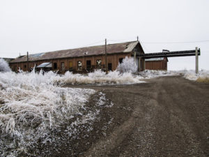
Underground storage tanks are an unwanted liability.
Underground storage tanks can leak, especially old rusty metal ones. People conducting real estate assessments and environmental engineers understand the importance of locating and, possibly, remediating underground storage tanks. On the other hand, not all tanks leak and not all tanks contain liquids that pose an environmental hazard. Moreover, not all liquids and materials stored below ground in a tank are hazardous (e.g., water). Common sources of contamination are gasoline, diesel fuel, heating oil, and solvents. Without doubt, metal underground storage tanks are easier to locate with geophysical instruments than plastic or concrete tanks. As one will find out, there are useful geophysical methods for locating both nonmetallic tanks and metal storage tanks. Even if they are beneath equipment or metal reinforcing material, there is a chance of detecting an underground storage tank.
How to find metal underground storage tanks.
Detect underground storage tanks using a magnetometer
Steel underground storage tanks are very common. The type of steel metal that a magnet is attracted to distorts the earth’s magnetic field. The distortion is far more for this type of steel than other types of metal. Moreover, the greater the amount of concentrated mass the greater the response. Thus, a magnetometer is a good choice for detecting steel tanks, even though anomalies are less definative. On the other hand, a magnet has little attraction for rust. That is to say, a rusted out tank may not respond very well to a magnetometer. However, this is not a common problem.
Types of magnetometers
The most common types of magnetometers are cesium vapor, proton precession, and flux gates. While the cesium vapor and proton precession magnetometers measure the earth’s total magnetic field, a flux gate magnetometer measures the strength in only one direction, often vertically. The first drawback of using a magnetometer is the lack of definition. Additional problems arise from noise or unwanted signal from cultural interference, solar flares, storms, and nearby steel. Magnetometer results are indifferent as to whether or not the tank is empty or full. In other words, a buried steel tank would likely yield the same response, if filled with gravel or water. On the other hand, if a steel underground storage tank was removed and the excavation back filled with steel car parts or other iron debris, one could easily misinterpret a magnetic anomaly as possibly being associated with an underground storage tank.
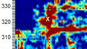
Find Underground Storage Tanks With a Magnetometer
Without doubt, the results of a magnetometer survey can vary. While the concentration of mass plays an important role, the geographic location, orientation, shape, and depth of burial are important. The placement and shape of an object with respect to the orientation of the earth’s magnetic field dictates if one should expect to map a dipole or monopole type event. The type of response determines if the measurements decay off by one over the cube of the distance (for a dipole) or by one over the square of the distance (for a monopole) from a magnetometer. Given that the magnitude of a measurement decays off exponentially with distance, the mapped response is, more or less, driven by the depth or distance a tank is from the magnetometer.
Articles about USTs
Article I
What are people saying about underground storage tanks in the media. Hundreds of Underground Tanks Leaking in Chicago City officials estimate nearly 1,800 tanks in Chicago require cleanup By Chris Coffey of Chicago’s NBC 5
Source: Hundreds of Underground Tanks Leaking in Chicago | NBC Chicago http://www.nbcchicago.com/investigations/Underground-Storage-Tanks-Creating-Toxic-Soil-231846081.html#ixzz4cj7MicZd Follow us: @nbcchicago on Twitter | nbcchicago on Facebook Chris Coffey of Chicago's NBC 5
Article II
Buried Trouble Detecting And Removing Underground Storage Tanks
Corroding USTs can pose several hazards, according to Daniel Swartzman, associate professor of health policy and administration at the School of Public Health of the University of Illinois at Chicago. Old buried tanks can collapse, rise above ground level or, more frequently, shift within the ground, pressing against and cracking the foundation of the home. There is also some potential for leaking tanks to contaminate well water, though such cases are unusual, says Swartzman, who also is a partner in the Chicago law firm of Schoenfield and Swartzman. “An old leaking tank could also release fumes into the basement, which could be ignited by an electrical spark or the pilot light on a water heater,” he says. “And those fumes contain known carcinogens, so even if they don’t ignite, they’re not the best thing to inhale.”October 14, 1994|By Jeffrey Steele. Special to the Tribune.
Electromagnetic Conductivity and TDEM measurements respond well to metal underground storage tanks.
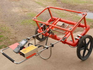
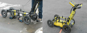
In my opinion, the biggest bang for the buck is to incorporate an electromagnetic instrument with a magnetometer survey. Unlike a magnetometer, electromagnetic instruments are sensitive to a variety of metals. Electromagnetic geophysical instruments like Geonics EM31-MK2, EM31-MK2 short, or an EM61-MK2 perform well and are easy to maneuver through commercial sites or industrial areas. However, the EM61-MK2 is difficult to operate over rough terrain. Given that the EM61 is also difficult to carry, its wheeled design lends itself best to locations that are smooth enough for the system to be wheeled across a site. On the other hand, Geonics designed the EM31’s and EM38’s to be carried by the instrument operator. This portability makes these two models ideal for areas with curbs, bushes, deep snow, small excavations, and other small obstacles.
Geonics EM31, EM61, and EM38
An EM61 or EM31 normal may detect large metal objects up to depths of about ten feet. An EM31 instrument is very sensitive to buried metal but requires more experience to operate than an EM61-MK2. Geonics designed the EM61-MK2 for the sole purpose of locating metal and is more sensitive to smaller near surface targets. It also has some capabilities for assisting with determining relative depth. In contrast to a Geonics EM31 normal, the EM31 short’s design reduces its depth of penetration by about 3 or so feet. For some very shallow investigations, a Geonics EM38-MK2 may yield desirable results. However, its depth of investigation is less than a few feet for buried metal.
Use Geonics EM31 to Locate USTs
When searching for an underground storage tank or its remains, one may wish to try to locate the original excavation. Unlike the EM61-MK2, which is strictly a metal detector, an EM31 measures both the apparent conductivity (quadrature phase) and magnetic susceptibility (inphase response). The EM31’s ability to measure soil conductivities can assist with locating fill areas or possibly void spaces. Without doubt, locating void spaces is a very difficult task. Yet, mapping variations in apparent soil conductivity is a routine geophysical survey. Assuming a site does not have a great amount of cultural interference, a Geonics EM31-MK2 can measure variations in apparent soil conductivity within +/- 5% error, for soils with an apparent conductivity of 20 mS/m. In other words, one may be able to identify sizable excavations filled with soils that are unlike the surrounding area.
Find underground storage tanks using GPR
Ground penetrating radar or GPR is an interesting near surface geophysical instrument. It has a wide variety of options that control its depth of investigation and resolution. As a result, GPR can assist with locating buried underground storage tanks (metal and nonmetallic), voids, fill material, trenches, soil conditions, and underground facilities. Targets need to be large enough to detect and have an electrical contrast that is great enough to create a reflection from the target of concern.
Use Geonics EM61 to Locate USTs
Why not use GPR
Without doubt, the first concern one has, when using GPR to search for underground storage tanks, is if the transmitted GPR signal can penetrate the subsurface, reflect off a target, and return to the GPR’s receiver. That is to say, “Can the GPR system detect the target?” Electrically conductive soils (e.g. saturated and/or clay rich) limit the depth of penetration of the GPR’s signal. In addition, areas with intermittent saltwater intrusion may have issues because the highly conductive residual salt found in the formation. In bad conditions, the GPR signal may only propagate a few feet or possibly inches. Unlike clay rich or saturated soils, GPR works best in areas with sand and gravel or rock. It also does well over ice; though, it is an unlikely place to find an underground storage tank.
Secondly, one needs to determine if the target is large enough to locate. This is not often a problem, when looking for underground storage tanks. It is more of an issue when attempting to locate buried pipes or wires associated with an underground storage tank. GPR systems using antennas with a center frequency between 100 and 500 MHz work well. Operators often use 200 MHz or 250 MHz antennas for these types of near surface geophysical surveys.
Find Underground Storage Tanks With GPR
What frequency GPR antenna is good
Given good soil conditions, one can expect greater depths of penetration with lower frequency antennas. Although higher frequency antennas may not penetrate as deep, they offer greater resolution. When attempting to locate an underground storage tank beneath concrete with reinforcing material, one may consider using a higher frequency antenna (e.g. 500 MHz). Unlike 100 to 250 MHz antennas, a 500 MHz antenna may allow the transmitted GPR signal to pass between metal reinforcing bars or wire mesh. However, there is no guarantee the signal will reach the target or produce desirable results.
When GPR works, it often produces spectacular results. When GPR fails, people often get very upset. They expect the equipment to respond the same at all sites. Of course, this will never happen. In addition to surface water, conductive soils, and target size, there are other factors that can compromise a GPR survey. For example, overhead electrical lines, metal fences, cars, and surface metal can produce reflections that may make it difficult to interpret the GPR results. Furthermore, good results are usually dependent on good coverage. Thus, one may find that survey areas with snow, bushes and/or trees, poles, trash containers, and other obstacles are difficult or impossible to survey with a cart type GPR system. Collecting GPR data manually without an odometer on a cart or GPS is a very time consuming task.
Search Industrial Sites for USTs
Electrical resistivity and underground storage tanks
Because underground storage tanks are often constructed of metal, the geophysical methods discussed above are the primary methods of investigation. However, there are times when these near surface geophysical methods are not a good choice. Complications arise with the presence of reinforced concrete. In addition, investigations pertaining to underground storage tanks commonly include mapping changes in soil units, characterizing the depth to bedrock, mapping a contaminate plume, finding fill, and looking for preferential paths for contamination to flow. With these objectives in mind, capacitance coupled towed resistivity arrays using a Geometrics OhmMapper or using multi-electrode electrical resistivity imaging methods can assist with these problems.
Some of the issues to address if one wishes to use an OhmMapper or other electrical resistivity method is target size, depth, electrical properties, and surface conditions. A towed capacitance coupled resistivity array does not physically penetrate the surface. It does not require electrodes placed in the ground to operate. This is not the case for conventional electrical resistivity, which uses electrodes to inject electrical current into surface soils. Thus, if the survey area is covered with pavement, it will be necessary to drill holes through the pavement. This allows the metal electrodes to make good electrical contact with the soils. Given that the holes are relatively small in diameter, drilling holes is seldom an issue. However, the process is time consuming.
Locate void spaces from underground storage tanks with MASW
Multi-channel analysis of surface waves or MASW is another excellent method to investigate for air filled or fluid filled voids (e.g. buried underground storage tank). The basic idea behind this approach is that surface waves only propagate through ridged or stiff material. Surface waves do not propagate through liquids or air. For that reason, surface waves do not pass through metal, plastic, or PVC storage tanks, unless they are filled with sand, gravel, or other stiff material. By analyzing changes in the characteristics of surface waves, one may detect the presence of an underground storage tank. An additional benefit of MASW is that surface metal is not a problem like it is for EM, GPR, and magnetometers. The method is also capable of mapping fill material and mapping depth to bedrock. Thus, one may be able to locate an old excavation or a bedrock depression.
Types of MASW
There are several approaches available for analyzing surface waves. The most common methods are MASW and Remi. Unlike passive MASW, active MASW surveys utilize a seismic source (e.g. a sledgehammer and plate). Passive MASW surveys analyze the seismic energy created by cars, trucks, trains, and other sources that cause the ground to vibrate from a, more or less, unknown geographic location. During acquisition, active MASW surveys look much like a seismic refraction survey or a seismic reflection survey.
Generally, passive and active MASW sources record data using 4.5 Hz geophones. Geophones with a center frequency of 4.5 Hz are much lower than geophones commonly used for refraction or reflection surveys. In my opinion, a MASW survey with an active source using 48 or more 4.5 Hz geophones is the best approach for investigations that require depths of penetration less than about 125 feet. As for the Remi method, I am more of purist and follow the standard MASW approach.
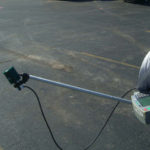
Track down an underground storage tank using a line locator
An indirect approach for locating an underground storage tank is to use a line locator. An underground line locator traces pipes and wiring to a common location. Some operators have managed to locate tanks using commercial line locators. In my opinion the previous methods often yield more desirable results. Dynatel, Pipehorn, Radiotronics, and Subsurface make several underground cable and pipe locators that work well. Some technicians have had success using a Schonstedt metal detector, which is a simplified magnetometer. This setup emits a whistling sound that varies with the strength of the magnetic field.
Fnd Underground Storage Tanks With Geophysics
Lastly, one may use a line locator to follow or trace the electromagnetic response given off by electricity passing through an active power line leading to a tank. In the United States, this means one attempts to follow a 60 Hz signal emitted from a buried hot wire. In my opinion, the method is not as reliable as one may think. Especially since it depends on current flowing through the wire. It also assumes that the surrounding area has little or no other 60 Hz transmissions. One may find it difficult to have great enough site conditions for a passive 60 Hz survey to deliver acceptable results within an industrial site or city.
Borehole geophysics
Unless boreholes are already available, there is one major drawback for using borehole methods to locate an underground storage tank. That is, a borehole tool requires a borehole to function. As a result, one may encounter an underground storage tank when drilling the hole. Thus, before conducting a borehole survey one may want to consider one or more of the previously discussed geophysical methods to assist with reducing the risk of hitting a tank.
Once a borehole is available, then a borehole magnetometer, a Geonics EM39, or borehole GPR tool may assist with determining if buried metal is nearby. Site investigations seldom use borehole methods because near surface geophysical methods work so well. An even less common geophysical method that may work for locating an underground storage tank is cross hole seismics. The method uses a Ballard downhole tool as an energy source. Data is recorded with a GeoStuff downhole geophone and a Geometrics Geode or other seismograph. The idea is that one may observe a loss of signal in the record if a buried tank interferes with the seismic pulse as it propagates from the seismic source to the receiver or geophone.

Locating Deep Facilities Using ERI, EM, MASW, pulseEKKO Ultra GPR, and Magnetometers for Buried Cables Voids Pipes
Geophysics for voids under buildings, floors, foundations, parking lots, and factories
Geophysical Services Conducted. A Short List of Clients, Landfills, Government Sites, and Locations.

Chart Comparing 57 Geophysical Methods With 17 Applications and Disciplines
Less Common Near Surface Geophysical Equipment
NAICS and SIC Codes for Geophysical Surveying and Mapping Services