Geophysical equipment for a wide range of applications and surveys.
It is nearly impossible to compile a definitive list of geophysical equipment used by all the possible applications and disciplines. Each geophysical investigation is unique and often lends itself to more than one geophysical approach. However, as a near surface geophysicist with over 33 years of experience, I can say that specific applications are not always associated with one type of geophysical equipment. For instance, I often receive requests to search for underground storage tanks ( USTs ) using GPR. Yet, GPR may not perform well at a site where the UST is buried beneath many feet of clay. In this case, EM and magnetometer surveys are often the most cost effective and reliable approach.
Consequently, professionals from different areas of expertise will find that the environment they work in may lend itself to a particular group of geophysical instruments (e.g. shallow verses deep, soils verses metal detection, or detection verses delineation). If you are interested in geophysical services, follow this link.
Electromagnetic Frequency Domain and Electromagnetic Time Domain Geophysical Methods
Electromagnetic geophysical surveys often use the following equipment
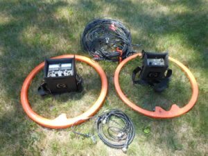
Geonics’ EM31 normal, EM31 short, EM38, EM34, EM61, G-Tem system, Protem Receiver with TEM47, TEM57, and TEM67 Transmitters, magnetic susceptibility meters from Geonics or TerraPlus’ KT 10.
Types of investigations that use electromagnetic frequency domain methods.
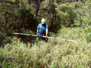
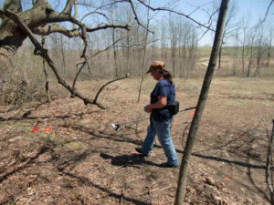
This group of geophysical equipment is valuable for collecting data over spatially large areas. Unlike electrical resistivity methods, it is difficult for EM to acquire shallow high-resolution results at a single location. Frequency domain EM is good at measuring bulk volumes of material. Hopefully, this will change with the development of Geonics TDEM G-TEM system. In the mean time, for very shallow geophysical services, one may choose to use a Geonics EM38 terrain conductivity meter. In contrast with the larger versions of this instrument, the EM38 has a depth of investigation from the surface to about five feet. It measures apparent soil conductivities and magnetic susceptibility, which makes it very sensitive to buried metal. Farmers, agricultural specialists, archaeologists, concrete and pavement inspectors, corrosion engineers, electrical engineers, environmental professionals, forensic scientists, geologists, hydrogeologists, mining specialists, real estate assessors, UST investigators, utility and line locators, and UXO specialists use this instrument.
Geophysical Equipment Geonics EM31
For investigations to a depth of about ten to twenty feet, a Geonics EM31 short or EM31 normal may work well. Like the EM38, the EM31 is sensitive to buried metal. Consequently, the same group of people utilize this instrument. Lastly, there is the Geonics EM34. Since it has a depth of investigation that is much greater than the EM38 or EM31, one may find it is not very helpful for locating buried metal. Its depth of investigation ranges from about 25 feet to 200 feet. Farmers, agriculture specialists, forensic scientists, UST investigations, line locators, utility locators, and UXO specialists may not find this instrument very useful.
Geophysical Equipment Geonics EM38
Types of investigations that use electromagnetic time domain ( TDEM ) methods.
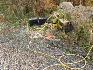
After about 200 feet of penetration, it is more practical to implement geophysical equipment that measures the transient EM response. This class of instruments, known as TDEM, can characterize subsurface conditions to great depths. Geonics manufactures a receiver (the Protem Reciever) that measures the response from their TEM47, TEM57, and TEM 67 transmitters. A smaller, more portable, TDEM system for depths of about 50 to 200 feet, is available. Geonics calls it the G-Tem.
While this group of geophysical equipment responds to depths less than 100 feet, it penetrates to depths greater than 3,250 feet. With the exception of the G-Tem, TDEM receivers generally need spatially large loops of wire at the measurement site. TDEM measurements are generally more awkward to acquire. This geophysical equipment is less friendly to use in the field than the frequency domain EM instruments. Electrical power and transmission line professionals, engineers, environmental specialists, geologists, hydrogeologists, and mine planners may benefit from this equipment.
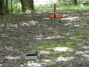
Geophysical Equipment Geonics G-Tem Protem
Special Electromagnetic Geophysical Surveys
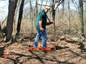
A Geonics EM61 is a metal detector that uses TDEM. Unlike the other Geonics instruments, this system is somewhat insensitive to variations in soil conditions. Given its excellent ability to detect, more or less, small amounts of metal at depth, unexploded ordnance specialists often use this instrument as well as others looking for buried metal, like buried drums, UST’s, or buried pipes. Hence, archaeologist, environmental specialists, farmers, real estate investigators, and many others utilize this instrument. While Geonics’ EM61 instrument is based on TDEM, it is not the only instrument to detect metal. The magnetic susceptibility or the inphase response of Geonics’ other instruments responds to the presence of buried metal. However, Geonics’ instruments sample a relatively large area. To measure the magnetic susceptibility of smaller geologic samples, one may decide to use a TerraPlus KT-10.
Geophysical Equipment Geonics EM61
Electrical Resistivity
Electrical resistivity geophysical surveys often use the following equipment and specifications
Geophysical equipment like Geometrics’ OhmMapper capacitance coupled resistivity with Res2DInv for post processing, AGI SuperSting R8 with 84 or more electrodes and EarthImager or Res2DInv for post processing, AGI MiniSting or Swift R1, Stainless electrodes or non-polarizable electrodes for self potential ( SP ) and induced polarization ( IP ) surveys are often taken to the field.
1-D Electrical resistivity soundings
Electrical resistivity soundings are an excellent choice for measuring apparent resistivity as a function of depth at a single location. If space and a large enough transmitter is available, there few limitations to how deep a resistivity sounding can penetrate. Unlike 2-D and 3-D resistivity surveys, a 1-D sounding provides information at a single location, like a boring. An inversion of the resistivity results indicates conditions at depth. For example, electrical resistivity soundings are important for establishing a ground plane along electrical power and transmission lines or at substation facilities. Electrical resistivity soundings also assist with determining the suitability for a multi-electrode resistivity imaging survey or for measuring the apparent electrical resistivities at great depths, usually over 250 feet deep. This method, unless it is moved across a site, offers great detail at only a single location and little assistance with mapping variations across a site.
2-D Electrical resistivity profiling
An improvement to a single electrical resistivity sounding would be to conduct many soundings across a site. On the other hand, one may decide to contour many electrical resistivity measurements acquired with one or two electrode spacings. Two electrode spacings would reflect two depths of penetration. Collecting hundreds of measurements throughout the site with one fixed electrode spacing or essentially a single zone of penetration produces a contour plot of apparent resistivity. The plot reflects changes in conditions at a pseudo depth, laterally across the site. The drawback with this approach is that it does not take into account changes that may occur above or below the zone of interest.
Geophysical Equipment Electrical Resistivity Tomography
Although one can characterize multiple depths of interest using additional array configurations, 2-D electrical resistivity profile surveys frequently use only one or two electrode spacings. In a similar fashion to the four pin or four electrode methods, Geometrics’ OhmMapper capacitance coupled electrical resistivity towed array is a great method for collecting electrical resistivity data over large sites. In contrast with the more conventional four pin or four electrode resistivity soundings, this geophysical equipment slides across the ground. Either a person tows the capacitance coupled array or pulls it with a setup designed for a user friendly vehicle.
2-D Electrical resistivity imaging surveys
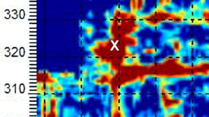
Unlike electrical profiles that map variations across a site, multi-electrode electrical resistivity imaging offers tremendous detail along a single line. One can create cross-sections of pseudo depth or modeled depth. A SuperSting R8 with 84 electrodes or an OhmMapper towed array works well for this application. The OhmMapper is designed only for a dipole-dipole array. Whereas, the AGI SuperSting multi-electrode configuration acquires data based on user selectable configurations. For example, an operator can configure the SuperSting R8 to acquire data using a Dipole-Dipole array, Schlumberger array, a Wenner array, Pole Dipole array, and various other arrays. One can also combine data acquired from more than one type of array. As a result, AGI’s SuperSting and Geometrics OhmMapper systems record thousands of apparent resistivity values. A computer can process the data using EarthImager or Res2DInv. The result is a detailed cross section of resistivity as a function of depth.
Numerous professionals benefit from this type of survey. Specifically, archaeologists have the potential to map graves, excavations, buried structures, and soil disturbances. Engineers, environmental professionals, geologists, hydrogeologists, mining professionals, and people who conduct real estate assessments benefit from multi-electrode electrical resistivity images. These people utilize the geophysical equipment to create cross sectional maps of the local geology, detect contamination, locate fill, find water, and detail many other subsurface features. Unlike the other electrical resistivity setups, AGI’s SuperSting (also MiniSting and Swift systems) cannot measure self-potential ( SP ). However, the SuperSting can map the effects of induced polarization ( IP ). These last two types of electrical surveys are useful for characterizing contamination, exploring for minerals, and detecting water movement around dams (e.g. seepage or leakage).
3-D Electrical resistivity imaging surveys
Conducting a pseudo 3-D electrical resistivity survey (e.g., acquiring parallel 2-D electrical resistivity lines) or by acquiring a true 3-D electrical resistivity data set are two of the greatest levels of effort in electrical resistivity. A geophysicist can present this data using software that reflects the conditions at depth in three dimensions. There is great interest for this type of survey. However, this geophysical method is costly and does not always provide more detail than the other electrical resistivity configurations. Nonetheless, the presentation of the results is often spectacular.

Ground Penetrating Radar ( GPR )
GPR surveys often use the following geophysical equipment and specifications
Sensors & Software, of Canada, has a product line that offers 12.5 MHz, 25 MHz, 50 MHz, 100 MHz, 200 MHz, Noggin 250 MHz, Noggin 500 MHz, and 1000 MHz antennas. Although they offer a variety of GPR geophysical equipment, the Noggin 250, Noggin 500, and pulseEKKO PRO systems are the most common. The acquired data allows post processing with EKKO_Project Software and EKKO_Mapper software. While collecting data, one can use a SmartCart or SmartTow to measure distance automatically along a survey line. The systems are also capable of recording DGPS data. In addition, one can move the equipment by hand and collect data along a marked line with or without DGPS.
2-D GPR imaging surveys
There are three common reasons for conducting GPR surveys along a single line, not a 3-D survey.
First reason for collecting GPR data along a single line.
First, it is beneficial to get a feel for how a site and its soils respond to GPR. When GPR works, it often yields spectacular results. However, electrical conductivity and dielectric properties (in addition to other factors) of the near surface material play a key role in the success of a GPR survey. By acquiring a few lines, one can quickly evaluate if GPR is going to respond to a zone or target of interest.
Geophysical Equipment Deep GPR
Second reason to avoid a large 3-D GPR survey.
The second reason for not conducting a 3-D survey is to survey very large areas. In other words, very large sites (e.g. 100’s of feet across) are time consuming, costly, and, more or less, impractical for conducting a 3-D GRP surveys. Of course, it would be nice to have 3-D GPR results. However, 2-D cross sections often provide good regional information and possibly a way to locate areas of concern for conducting a 3-D GPR survey.
Third reason not to conduct a 3-D GPR survey.
Lastly, GPR operators frequently need to look for buried pipes, cables, wire, utilities (best left to the utility companies), and other buried facilities before excavating or boring a hole. While I generally recommend 3-D GPR imaging for all situations except for the second reason above, clients are generally not willing to take the additional time or spend the money needed for results that yield a higher level of confidence and more detail.
3-D GPR imaging surveys
With EKKO Mapper software a computer can process spatially referenced GPR data to plot 3-D images. These images provide detail that is often difficult to visualize in 2-D results. After all, the mind can only sort through or process a limited amount of information without being overloaded. In contrast, a computer is capable of filtering out thousands of unwanted or unreasonable responses before combining the data into a 3-D image.
While 3-D results are nice, it is often more practical to view the 3-D results in plan view. Thus, one can generate plan view plots for incremental slices in depth. Each slice represents an increase in depth of penetration. For instance, a plan view slice is commonly plotted at one-inch increments for concrete scanning or every foot for geologic characterizations. One drawback of a 3-D GPR survey is the fact that the software is more than willing to create an image with little or no data, which is clearly the operator’s responsibility. Thus, it is very important to collect lines that are closely spaced and that cover the area of concern.
Geophysical Equipment Noggin 500 MHz
Who needs GPR surveys?
Because GPR can image very small features (e.g. cracks, nails, or bullets) as well as very large targets (e.g. faults, bedding planes, graves, drums, UST’s, pipes, tiles, contamination, and other), GPR has the potential to assist anyone wanting to locate a target beneath the surface of soil, rock, concrete, water, wood, asphalt, plastic, ice, and other nonconductive media. People working in the areas of agriculture, archaeology, concrete and pavement, corrosion, electrical power and transmission line facilities, engineering (non-environmental), environmental, forensic science, geology, hydrogeology, mining, real estate assessments, underground storage tanks ( UST’s ), utilities, buried metal cables, underground pipes, and unexploded ordnances ( UXO ) benefit from geophysical equipment like GPR.
Seismic Methods
Seismic geophysical equipment for near surface surveys
The geophysical equipment for these types of investigations often include Geometrics’ Geode, Ballard borehole source, GeoStuff triaxial geophones, 2 Hz or 4.5 Hz geophones for MASW, an accelerated weight drop like a 700 lb elastic wave generator, 4.5 to 40 Hz geophone for Seismic Reflection and Seismic Refraction, a 10 to 20 lb sledge hammer, and processing software for MASW, refraction, reflection, or refraction micro-tremor ( ReMi ) surveys.
Geophysical Equipment Seismic Reflection
Applications for seismic surveys
Like GPR and electrical resistivity imaging, seismic methods lend themselves to creating cross sections. Unlike GPR, seismic energy is much lower frequency. It is best suited for greater depths of investigation. Generally, near surface seismic surveys investigate greater than ten feet and up to thousands of feet. Near surface seismic surveys using geophones placed along a line work well for mapping overburden thickness, the water table, and imaging bedrock. Sites well suited for seismic methods can map large fracture zones, faults, karst zones, and weathered rock. Seismic surveys with geophysical equipment like Geostuff’s triaxial borehole geophone(s) and/or a Ballard borehole seismic source are more for creating a vertical profile at a single location, like a boring log. Seismic methods seldom lend themselves to professionals conducting corrosion surveys, electrical power and transmission line studies, magnetic susceptibility surveys, locating buried facilities, and UXO studies.
Sub-bottom profiler surveys
This category of geophysical equipment is the last of three geophysical methods that depend on reflected energy. As a result, GPR, seismic reflection, and sub-bottom profiling are very similar. The results present the time it takes for either seismic energy or electromagnetic energy to travel through the subsurface, reflect off of a target, and return to the system. Engineers, mine operations that dredge, geologists, and professionals who maintain waterways and harbors are some who benefit from sub-bottom profile surveys.
Although there are several manufactures and designs of sub-bottom profilers, only a few lend themselves to inland waters. For example, two U.S. companies (SyQwest and JW Fishers) manufacture high-resolution sub-bottom profilers that function over the bow of a boat. A third company (EdgeTech), has a towed system that is for shallow water. Given that this equipment operates in bodies of water, one needs to have a boat and GPS to utilize this geophysical equipment.
Borehole Geophysical Tools
Note the discussion here is somewhat limited, given the extent of the borehole geophysics industry. Although the oil and gas industry uses many of these downhole instruments, this discussion focuses on borehole tools commonly found in near surface geophysical applications. While there are numerous manufactures, the examples here are manufactured and/or distributed by Mt. Sopris, with the exceptions of the Geonics EM39, the Ballard shear wave source, and the Geostuff downhole geophone.
Who uses borehole tools
Geologists, engineers, hydrogeologists, environmental specialists, and underground storage tank investigators are some of the biggest users of borehole tools for near surface geophysics. Archaeologist, forensic scientists, real estate assessment specialists, corrosion specialists, and electrical power and transmission line professionals are likely to use only a select number of these borehole tools. UXO specialists tend to use a borehole magnetometer, a Geonics EM39, and borehole GPR.
Geophysical Equipment Geometrics Magnetometer
Borehole conditions and characterization
For two basic reasons, one must pay close attention to borehole conditions. First, water quality, temperature, and flow are generally important factors for understanding conditions at depth. Though these factors stem from conditions within the formation, they are quantities that are measured within the annulus of the borehole and not typically part of the formation. Secondly, the condition of the borehole can strongly effect the results that the tools measure, which characterize the formation. For instance, a 3 Arm Calipers QL40-CAL can assist with measuring changes in the borehole diameter. Variations in the diameter of a borehole can assist with characterizing formations and identifying conditions that can compromise the results of other borehole tools. For example, variations in the diameter of a borehole can affect the responses of centralized natural gamma or EM39 tools.
A probe like the Fluid Conductivity and Temperature QL40-FTC tool assists with determining water quality and temperature. Probes like the Impeller Spinner Flowmeter FLP-2492 QL40-SFM and Heat Pulse Flowmeter HFP-2293 tools assist with understanding the movement of ground water and/or other borehole fluids. While an Optical Borehole Imager OBI40-2G scans the inside of the borehole to create a color image, an Acoustic Televiewer QL40-ABI-2G creates a graphic image. The Acoustic Televiewer’s image is based on the travel time and change in amplitude of a reflected ultrasonic beam. When characterizing the seismic velocities of formations at depth using geophones or seismic sources at the surface, the deviation or the straightness of a borehole is important. Velocity calculations can be in error if the borehole is not vertical. Thus, one can determine the “straightness” of a hole using a borehole Deviation QL40-DEV tool.
Formation characterization
Changes in lithology, formation properties, porosity, and permeability are often reflected in the electrical properties of a formation. The natural radiation emitted by rock and soils is also an important diagnostic tool. Thus, borehole tools like the Natural Gamma with SP SPR 16 64” Normal Resistivity, the Electrical Resistivity Probe IP and 4-point Resistivity QL40-ELOG, the Normal Resistivity 8/16/32/64″, Geonics EM39 (borehole) Induction 2PIA-1000, the Full Waveform Sonic 2SAA-1000 QL40-FWS, and the Spectral Gamma 2SNA-1000S QL40-SGR are commonly used for characterizing formations.
Geophysical Equipment Optical Borehole Imager
Though in mineral exploration borehole tools like the Magnetic Susceptibility (borehole) QL40-HM or Magnetometer (borehole) can assist with locating concentrations of iron, these tools and borehole GPR are able to detect metal. This is especially important to UXO investigators. Finally, geologic units have a Vp and S-wave seismic velocity. Changes in seismic velocities at depth may identify formation boundaries. Unit seismic velocities are also important for seismic reflection, seismic reflection, and MASW surveys. Unit velocities are often determined using a full wave sonic tool or a downhole seismic source (e.g., Ballard borehole seismic source) in conjunction with surface geophones or a borehole geophone (e.g. Geostuff’s triaxial borehole geophone).
Locating Deep Facilities Using ERI, EM, MASW, pulseEKKO Ultra GPR, and Magnetometers for Buried Cables Voids Pipes
Geophysics for voids under buildings, floors, foundations, parking lots, and factories
Geophysical Services Conducted. A Short List of Clients, Landfills, Government Sites, and Locations.

Chart Comparing 57 Geophysical Methods With 17 Applications and Disciplines
Less Common Near Surface Geophysical Equipment
NAICS and SIC Codes for Geophysical Surveying and Mapping Services
Geophysics and Geophysical Services From Archives and Old Posts