Geophysical Services Related to Engineering Geophysics
Engineering geophysical methods often relate more towards quantifying material properties than mapping local or regional changes across a survey area. There is a significant amount of overlap between the discussions on engineering geophysics and other pages found at GeophysicalServices.com. In other words, some types of studies lean more towards engineering than geology, environmental, or ground water issues.
Parallel seismic survey methods
Locating a pile tip or the bottom of a sheet pile is a great concern for engineers. The failure of a sheet pile or of a foundation for a bridge or building can depend on its depth. Parallel seismic survey methods, tests, and instruments has its own section. The method offers a borehole seismic approach for estimating the depth of a pile tip or sheet pile. Although it has its limitations, parallel seismic surveys offer a cost effective and reasonable approach. People interested in redesigning the load capacity or reusing abandoned piles for a new application use parallel seismics to solve engineering problems.
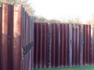
Parallel seismic surveys measure the depth of sheet piles and foundations.
Engineering geophysics for electric power
Many facilities require ground plains that are site specific. The design depends on how well the subsurface can conduct electricity. Specifically, four electrode electrical resistivity soundings (1-D resistivity) quantify or measure increases in apparent resistivity as a function of depth. This electrical resistivity method assists with the design of power stations, electrical substations, cathodic protection systems, pipelines, and building sites. The measurements characterize the apparent soil resistivities of in situ soils and rock.
For engineering applications, ASTM standard G57 and ANSI/IEEE Std 81 define how to conduct two, three, and four electrode electrical resistivity surveys.
Standard Test Method for Field Measurement of Soil Resistivity Using the Wenner Four-Electrode Method
The ASTM standard G57 states
1. Scope. 1.1 This test method covers the equipment and procedures for the field measurement of soil resistivity, both in situ and for samples removed from the ground, for use in the control of corrosion of buried structures.
In contrast to the ASTM standard G57, which is about the Wenner four-electrode method, IEEE’s ANSI/IEEE Std 81 discusses other techniques. For example, ANSI/IEEE Std 81 standard describes the Two-Point method, Three-Point method, Four-Point method, Ratio method, Staged Fault test, Fall-of-Potential method, and other types of electrical measurements.

Engineering Geophysics for Power Plants
IEEE Guide for Measuring Earth Resistivity, Ground Impedance, and Earth Surface Potentials of a Ground System
The guide states
1. Purpose
1.1
It is the purpose of this guide to describe and discuss the present state of the technique of measuring ground resistance and impedance, earth resistivity, potential gradients from currents in the earth, and the prediction of the magnitudes of ground resistance and potential gradients from scale model tests. Factors influencing the choice of instruments and the techniques for various types of measurements are covered. These include the purpose of the measurement, the accuracy required, the type of instruments available, possible sources of error, and the nature of the ground or grounding system under test.
1.2
The guide is intended to assist the engineer or technician in obtaining and interpreting accurate, reliable data. It describes test procedures which promote the safety of personnel and property, and prevent interference with the operation of neighboring facilities.

MASW for Wind Farms
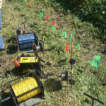
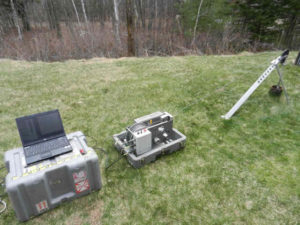
Electrical Resistivity Equipment for 2100 ft Wenner Array Sounding
Engineering geophysics for measuring the velocity of shear waves and compressional waves.
The propagation of seismic shear waves and the analysis of shear wave velocities are helpful for determining the shear strength of rock and soils. Although the velocities of compressional waves are important, it is generally more difficult to determine shear wave velocities. Once the shear wave velocities are known, one can estimate the stiffness of the soils. Until recently, shear wave geophones placed along a line at the surface directly measure shear wave velocities. These days, a method called multi-channel analysis of shear waves ( MASW ) is very popular. MASW has an entire web page dedicated to this topic. The result of a MASW survey is a cross-section of shear wave velocities versus depth. Furthermore, the stiffness is one property that determines the suitability of a site for constructing buildings, dams, bridges, or roads.
Borehole Seismic Survey
From an engineering standpoint, one can calculate P-wave velocity, S-wave velocity, Young’s modulus, density, or Poisson’s ratio. However, one must know three of these five values. However, Poisson’s ratio is dependent on only P-wave and S-wave velocities, which are available from various seismic surveys. So that the calculations are reasonably accurate, the sub-surface conditions must be, more or less, homogeneous and isotropic.
Engineering geophysics for levees
Engineers design levees. The ability of a levee not to fail with saturated ground water conditions or to hold back floodwaters is strongly dependent on the engineering design. A levee design frequently incorporates the use of local materials. The consistency of local materials often varies more than sands, gravels, and clay rich soils from a quarry or open pit. Thus programs are put in place to characterize the engineering properties of the local soils. The mixture of clay, sand, gravel, and/or rock determines the electrical properties and the stiffness of the materials.

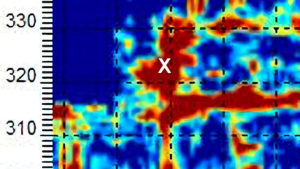
Engineering Geophysics On A Levee Investigation
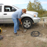
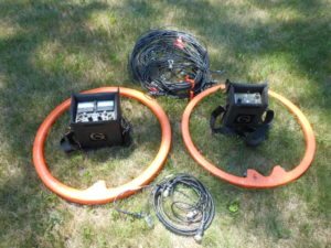
A program to characterize the local soils for constructing a levee may include electrical resistivity tomography methods or seismic surveys. Unlike electrical resistivity tomography, which has two primary methods of acquiring data, there are several seismic methods for determining the propagation velocities of materials. By using a seismograph (to record data), down hole geophones, a down hole ballard shear wave source, and/or geophones along the surface one can calculate the velocity of compressional waves and shear waves as they propagate.
Engineering geophysics for ground vibration monitoring
Ground vibration monitoring is a reliable and quantitative engineering method. It assists with determining if your home, business, or machinery are at threat. People are far more sensitive to ground vibrations than what it takes to damage a building. Years ago it was apparent there was a desperate need for rigorous guidelines. Thus, in 1974, the Bureau of Mines found it necessary to investigate and analyze the damage to buildings from blasting. The blasting was from near by mine operations. The study was able to document and correlate ground vibrations with the potential for structural damage to buildings.
Subsequently, the program produced document RI8507, STRUCTURE RESPONSE AND DAMAGE PRODUCED BY GROUND VIBRATION FROM SURFACE MINE BLASTING.
The abstract for RI8507 states, “The Bureau of Mines studied blast-produced ground vibration from surface mining to assess its damage and annoyance potential, and to determine safe levels and appropriate measurement techniques. Direct measurements were made of ground-vibration-produced structure responses and damage in 76 homes for 219 production blasts. These results were combined with damage data from nine other blasting studies, including the three analyzed previously for Bureau of Mines Bulletin 656.”

Engineering Geophysics for Monitoring Ground Vibrations
Today, RI8507 is a standard for many local and state governments. Surely, severe ground vibration can lead to incredible damage. However, the harsh reality for many homeowners is that ground vibrations from construction, blasting, industrial sites, and trains are often a greater nuisance than a real threat. Ground vibrations will cause lamps or chandeliers to shake and windows to rattle. These vibrations may not lead to structural damage. In short, the only clear way to argue that one’s home or business is at threat is to hire an independent third party to monitor, record, and report the results. These results are a starting point for taking action.
Engineering geophysics using a sub-bottom profiler
Sub-bottom profiling lends itself to engineering applications. As an example, dredging, mapping sediment thickness behind dams, characterizing bottom conditions, and mapping fill. Specifically, the characterization of materials beneath the bottom of a lake, river, bay, or other is often an engineering concern. Sub-bottom profile results are very similar to ground penetrating radar ( GPR ). Unless the results of a sub-bottom profile survey have descriptions, one would easily think they are looking at a cross-section from a GPR survey. The results of a sub-bottom profile survey can assist with reducing the number of borings drilled using an offshore platform. This topic is large enough that GeophysicalServices.com has a separate page about sub-bottom profiling applications, click here.
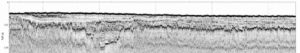
Sub-bottom Profiling for Engineering
Well logging or borehole logging for engineering geophysics
Though confined to a boring location, geophysical borehole logs can measure porosity, permeability, bulk density, elastic properties, clay content, secondary porosity, water quality, water flow, temperature, video well construction and borehole conditions, detect and map contaminate plumes as well as detect the presence of metal. Engineers can characterize many of these properties using one or more borehole tools. However, it takes a special license to measure porosity and bulk density using a nuclear source. Many engineering firms are uncomfortable with the terms for conducting these logs.
Borehole Logging for Engineering Geophysics
Locating Deep Facilities Using ERI, EM, MASW, pulseEKKO Ultra GPR, and Magnetometers for Buried Cables Voids Pipes
Geophysics for voids under buildings, floors, foundations, parking lots, and factories

Geophysical Services Conducted. A Short List of Clients, Landfills, Government Sites, and Locations.

Chart Comparing 57 Geophysical Methods With 17 Applications and Disciplines
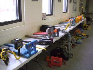
Less Common Near Surface Geophysical Equipment
NAICS and SIC Codes for Geophysical Surveying and Mapping Services