MASW seismic testing surveys
MASW investigations function in geologic conditions that are often unsuitable for seismic reflection or refraction methods. By all means, seismic refraction and reflection surveys play a key role that other geophysical methods cannot replace. First, it may be easier to describe what MASW doesn’t do when asking how does it work. Seismic reflection and refraction surveys are driven primarily by the propagation of compressional P wave velocities. These surveys respond to the geology in a way that is different from MASW. MASW does not depend on recording seismic refractions or seismic reflections. The geophysical method is dependent on recording the effects of dispersion along an array of geophones.
MASW is not impacted, like refraction surveys, by perched water or problems with low velocity layers at depth. While refraction surveys are commonly used for mapping the top of bedrock, refraction methods are only able to map sand and gravel units (generally a lower velocity geologic unit) if they are not located below a higher velocity unit (e.g a clay unit). If left undetected, the sand and gravel unit can compromise the refraction results. Seismic reflection surveys are far more forgiving and capable of detecting or delineating features not observed in a refraction survey. However, shallow reflection surveys, less than 100 feet are a challenge for the geophysicist and are expensive to acquire. MASW does not experience either of these issues.
What is MASW
MASW is an acronym or abbreviation for multi-channel analysis of surface waves. What is multi-channel analysis of surface waves? It is the process of studying how surface waves change (disperse) as they propagate across a site. Specifically, how the seismic energy changes as it progresses along an array of geophones. Unlike other seismic waves, surface waves or Rayleigh waves disperse in a way that allows geophysicists to analyze the transformation using post-processing software. In the end, the sophisticated software creates models of real conditions that could produce the dispersion observed in the seismic records. Until now, surface waves were frequently considered a nuisance. These waves often complicated the seismic record and made it difficult to interpret seismic refraction and seismic reflection results. Today, 8 to 20 pound sledge hammers up to 7000 ft-lb elastic wave generators (deep penetration) produce surface waves or Rayleigh waves for MASW surveys.
Why use MASW
MASW seismic surveys offer a geophysical method to assist with measuring the stiffness of the subsurface material. Areas of concern often correlate well with variations in soil stiffness at depth. While it is obvious that competent rock is stiff, it is not always apparent to others that saturated and unsaturated voids respond the same. Thus, we have a geophysical method where the seismic energy will not pass through unsaturated or saturated voids and responds well to materials that range from unconsolidated soils to competent rock. Consequently, the geophysical survey is able to assist with geologic surveys, foundation studies, and mapping past human activities.Geophysical Services LLC has specific MASW equipment for exploring very shallow depths less than 25 feet, shallow depths between 25 and 50 feet, medium depths between 50 and 100 feet, and more specialized equipment for depths between 100 and 200 feet.
MASW for characterizing geology
MASW responds well to the contact between unconsolidated soils and bedrock. In fact, the geophysical method can map weathered zones at the top bedrock. Unlike refraction surveys where perched water can complicate the results, fluids do not generally impact MASW surveys. In addition to bedrock surveys, mapping fault zones and changes in soils (e.g. sands changing to clays, variations in cementation, and changes in porosity) are not beyond an MASW investigation.
Shallow Active MASW Survey
MASW for geotechnical studies and foundation surveys
Since MASW responds to changes in stiffness that correlate to variations in density, porosity, and cementation, engineers are able to use the results to assist with evaluating the soil conditions for building. Given that karst conditions are a problem for building sites, this seismic method is frequently used to assist with locating karst features and other void spaces. Fill is often a problem. A survey can help characterize the extent of fill and its degree of compaction. Lastly, contractors use grouting to control the movement of water and to improve soil conditions. A well planned out investigation can aid with mapping the progress or the end result of a grouting program.

MASW for mapping human facilities or structures
MASW is not particularly responsive to small features. As a result, it is not a tool for locating buried pipes and cables. On the other hand, large scale features, such as, tunnels, bunkers, septic tanks, and underground storage tanks ( UST’s ) are potential targets for this type of geophysical survey. Buried below grade structures like a basement or structures used to contain leaks from UST’s are potential geophysical investigations. Return to the main page for information on geophysical services for private facilities.
How does MASW work
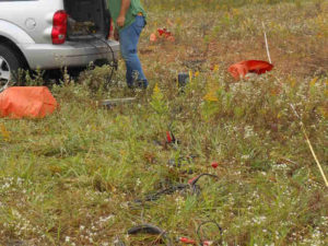
MASW starts by acquiring data that reflects the changes surface waves experience while propagating across and area of concern. Data acquisition is fairly straight forward. One simply records variations of ambient noise (passive survey) from cars, trucks, trains, and other or from a maned seismic source (active survey). For active shallow surveys, generally less than 75 feet deep, a large sledgehammer and plate works well. However, for depths greater than 100 feet one may want to consider using a much larger MASW source. There are very good reasons to collect both active and passive data. Collecting both active and passive MASW results produces a more robust data set. One that assists with reducing the number of possible solutions during post processing.
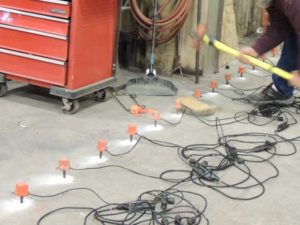
Very Shallow MASW Survey for Buried Walls
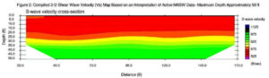
Passive MASW surveys collect data in a large variety of configurations. In fact, passive surveys can have the geophones placed at random locations, given one can place them on an X-Y coordinate system. Active MASW surveys are also very flexible. However, there are two popular options. The first option yields a 1-D presentation that reflects the conditions at depth over, more or less, a fifty-foot area. The coverage is similar to the results provided by a single borehole. The second option yields a cross-section. The 2-D cross section yields modeled shear wave velocities (Vs) verses depth along the MASW line. In general, sand/gravel, clay, silts, rock, and fill material have different shear wave velocities.
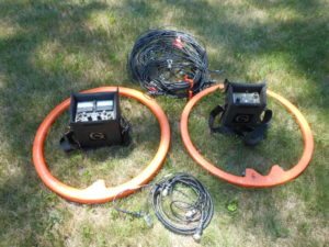
MASW equipment
As with any geophysical survey, one needs to pay close attention to the survey setup and configuration. A MASW equipment list includes a seismograph, geophones, a source, and software of processing the data. I have found a 24-channel seismograph is often suitable for use with a land streamer or if one decides to roll through a 48-geophone array. In my opinion, MASW surveys areas are often confined to an area too small for towing a land streamer. In these cases, I have found a 48-channel seismic system may work well in less complicated areas or if adjustments are made. To repeat, a hammer plate and sledge generally produces good results for shallow surveys.
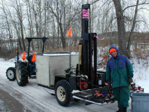
Powerful 7000 ft-lb MASW Source for Deep Surveys
For deep investigations, only a large energy source will produce the power necessary to create large wavelength surface waves. However, one should also pay attention to the selection of geophones. Without doubt, 4.5 Hz geophones are the most common. This does not mean they will work at every site. If the area of concern is less than forty feet deep, it is reasonable to consider using higher frequency geophones (e.g. 30 to 40 Hz). For very deep MASW surveys one may consider 2 Hz geophones. In the same way the frequency and wavelength of the energy drives the depth of investigation, the geophone spacing and the location of the shot points or hammer plate are important. The length of a MASW survey line and the size of the site can play an important role in establishing the geometry selected for the MASW survey.
MASW software
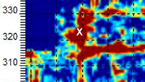
Finally, MASW data requires processing. Under good conditions, the data processing procedure frequently yields reasonably good dispersion curves. By analyzing and interpreting dispersion images one can approximate the fundamental mode for a group of records. The processing software utilizes picks obtained during the interpretation process to yield an inversion model of the fundamental curves. The inversion process then yields a 1-D shear wave velocity verses depth panel for each image. When acquired, 1-D panels are averaged together to create a 2-D Vs map along the MASW line. Please beware that MASW surveys do not yield unique results and the geophone array covers a larger area at the surface than at depth. In addition, units at depth need to be large enough and have a great enough velocity contrast for the inversion process to yield desirable results. Like other geophysical methods, the horizontal and vertical resolution decreases with depth.
The acquisition, data processing, analysis, and interpretation generally produces a cross-section of shear wave velocities as a function of depth. Unlike borehole shear wave surveys that generate results at a single location, a MASW test yields results that are for 10’s and even 100’s of locations along a line. The geophysical software produces the final output or cross-section. Although ParkSeis is my favorite, other products are found on the market. Geometrics, a manufacture of seismic equipment, offers software called Geometrics’ SeisImager SW package. One of the first software packages, created by a government agency, is from the Kansas Geological Survey, called SurfSeis MASW Software. Choon Park, one of the developers of KGS’ SurfSeis, came out with his own software package, called ParkSEIS. Without doubt, Choon is dedicated to MASW and there when you need help.
Geophysical Services MASW Survey
Credit to hard working people
Given the volume of information available on MASW, it is nearly impossible to give credit to all of those who have advanced the seismic industry. While this web page is lite reading, these and others have made contributions to the geophysical community that I am sure I have learned from. In alphabetical order: J.M. Anderson, J. Ivanov, J. B. Harris, J.A. Hunter, D. Laflen, R. D. Miller, C.B. Park, N. Ryden, P. Ulriksen, and J. Xia.
Locating Deep Facilities Using ERI, EM, MASW, pulseEKKO Ultra GPR, and Magnetometers for Buried Cables Voids Pipes
Geophysics for voids under buildings, floors, foundations, parking lots, and factories

Geophysical Services Conducted. A Short List of Clients, Landfills, Government Sites, and Locations.

Chart Comparing 57 Geophysical Methods With 17 Applications and Disciplines
Less Common Near Surface Geophysical Equipment
NAICS and SIC Codes for Geophysical Surveying and Mapping Services
Geophysics and Geophysical Services From Archives and Old Posts