Introduction to Geophysical Services
Undoubtedly, there is a wide variety of geophysical services available, far too many to cover in this site. Although the characterization of our planet’s geology comes to mind, geophysical instruments are capable of mapping variations of numerous physical properties. For instance, geophysical instruments can measure changes in electrical conductivity, electrical resistivity, elastic properties, density, porosity, magnetic fields, electromagnetic fields, saturation, and numerous other physical properties. Consequently, a diverse group of geophysical services emerges from the methods available for using the geophysical instruments. Follow this link to find geophysical instruments and applications.
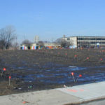
Geophysical services are available for studies involving geology, environmental remediation, hydrogeology, mining, oil and gas exploration, engineering geophysics, real estate assessments, concrete scanning, archaeology, ground vibration monitoring, magnetic susceptibility, shear wave analysis, forensic science, and agriculture. One must always keep in mind that the geophysical instruments are not crystal balls. By all means, the equipment responds to the conditions at depth. However, interpretations of the results may not reflect the true conditions at depth.
Geophysical Services for Geologic Studies
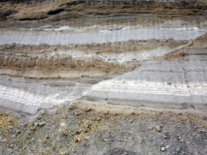
While one can test for numerous soil and rock properties in a laboratory environment, only large-scale changes in electrical or physical properties are observable in the field. Bedrock studies and soil surveys using geophysical methods lead to mapping geologic features. For example, fractures, joints, faults, changes in bedrock topography, and the effects of weathering on bedrock. Furthermore, geophysical applications can map out changes in sand and gravel units or lateral variations within rock units that lead to fluctuations in saturation and/or porosity.
Without doubt, the key is in how extreme or how great the contrast is between areas of concern and is the area of concern large enough to map. In general, the contrast between geophysical properties must become greater with depth. In addition, the area of concern must increase in size with depth, and/or both situations must occur. The discussion about how geophysical applications apply to geology covers a lot of territory. It is, more or less, a common denominator between many of the areas of study listed below. Thus, it is more interesting to move on. Below is a discussion on how geophysical methods apply to various areas of interest.
Geophysical Services for Geology
Geophysical Services for Environmental Remediation
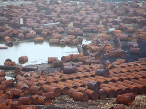
Pollution is a major concern for everyone. Unlike air and noise pollution, searching for hazardous waste and the collateral damage from the improper disposal of hazardous waste are targets for geophysical surveys. Buried hazardous materials can affect the subsurface in many ways. Unless one is mapping preferential paths that correlate with bedrock elevations, electrical methods are a preferred geophysical service for environmental remediation investigations. In comparison to electromagnetic surveys that have only a few techniques of acquiring data, electrical methods offer a wider selection of geophysical instruments and applications. For example, electrical methods for environmental studies generally include electromagnetic conductivity instruments, electrical resistivity equipment, and ground penetrating radar systems. These three groups offer numerous choices that target various depths of investigation and respond to a large number of subsurface conditions, including changes in a bedrock surface. For the purpose of bedrock surveys, seismic methods may provide the best results.
Metal detection
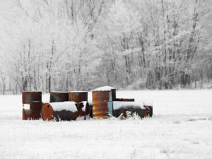
Geophysical Services for Environmental Remediation
Many electromagnetic instruments, such as, GPR and Geonics’ EM61, EM31, and EM38, respond to different types of metal. However, a magnetometer responds primarily to fluctuations in the earth’s magnetic field. The fluctuations are, more or less, due to ferrous metal. Specifically, the type of ferrous metal that a magnet fastens to. In contrast with GPR, electromagnetic conductivity instruments and magnetometers have a tendency to respond to metal over a spatially larger area. Furthermore, they are often better at detecting metal at greater distances from the instrument for less cost. Since a GPR system images targets that are essentially beneath the instrument, it offers greater resolution. Often within a smaller zone of investigation. In other words, GPR can provide greater resolution but will cost more to investigate the same size survey area than with the other instruments.
Summary
Thus, geophysicists use cost effective methods like electromagnetic instruments and magnetometers to locate buried metal such as drums, rail cars, and underground storage tanks. On the other hand, multi-electrode electrical resistivity imaging instruments and electromagnetic terrain conductivity meters map changes in soils, rock, landfill material (e.g. ash, municipal fill, and foundry sand), and ground water contamination. For example, these last two methods can map contamination from fuel (e.g. jet fuel, diesel fuel, or gasoline), PCB’s, drilling fluids (e.g. fracking), salt water, cleaning solvents, and paint. Consequently, many Superfund sites are uncovered using the above methods and instruments. Follow this link to find out more about environmental remediation.

Geophysical Services for Hydrogeology Studies
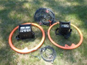
Unless one is looking to drill very shallow wells, hydrogeologic studies use deeper penetrating geophysical methods. For instance, geophysical instruments for hydrogeologic studies include Geonics EM34, Geonics Protem Time Domain Electromagnetic system ( TDEM ), seismic refraction, seismic reflection, multi-channel analysis of surface waves ( MASW ), and multi-electrode electrical resistivity imaging using an AGI SuperSting R8. Geophysical methods using these instruments often delineate bedrock valleys, identify lateral variations in rock units or rock types, detect salt-water intrusion, and locate joints, fractures, and faults.
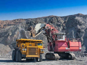
Geophysical Services for Mining Operations
Mining operations can utilize nearly all of the geophysical services shown on this site. Because mines cover a large footprint, it is difficult to project reserves or conditions at depth solely on drilling results. Geophysical services can assist mine operations with establishing a drilling program or corroborating the conditions between drill holes. Geophysical services for mining applications can include frac sand, sand and gravel pits, above ground limestone quarries, granite for building materials and railways, mineral exploration, diamonds, gold, marble, salt domes, and underground limestone mining. Certainly, this list represents only some of the possibilities.
Cost effectiveness of geophysical services for mining
A cost effective approach for investigating a mine facility is to collect low-resolution data across the entire site. Specifically, one must use a geophysical method that is highly portable and relatively inexpensive to operate. For example, Geonics’ terrain conductivity meters and Geometrics’ OhmMapper capacitance coupled resistivity meter are capable of mapping lateral variations across 100’s or 1000’s of acres. On the other hand, these instruments do not generally offer the detail necessary for mapping changes at depth at a specific location. Thus, one uses the data from the first phase to focus on zones of interest that require greater definition. For this phase, higher resolution geophysical methods can provide detail along a line or at a single point (e.g., multi-electrode electrical resistivity imaging system, seismic methods, horizontal and vertical dipoles with multi-coil spacings using a Geonics EM34, and/or multiple passes with an OhmMapper).
Geophysical Services for Mining
Geophysical services case history
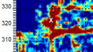
One of the more unique case histories I was able to work on was creating 3-D models of kimberlite pipes. The services were for a diamond mine in the Arctic Circle. During the startup phase of the mine, it was important to decide which kimberlite pipes would yield the best production. Thus, the task was to determine which kimberlite pipes were the largest at depth. If the pipe was sufficiently large within the minable depth of the operation then it was a good choice. The worst case was if the pipe became narrower with depth. If this happened, the volume of material available to mine for diamonds would decrease with depth.
Geophysical Services for Real Estate Assessments
Undoubtly, real estate assessments involve the potential for environmental issues (see environmental remediation above). On the other hand, real estate assessments can also pertain to documenting underground storage tanks ( UST ), finding septic systems, mapping tile lines, and locating private facilities. Locating private facilities can encompass buried pipes, cables, water lines, wires, and other artifacts. Primarily because of liability issues, locating public utilities is best left to the organizations authorized to do so.
Searching for UST’s is a common problem. This topic is popular and has its own page. Another problem, dealt within real estate assessments, is looking for fill material. Attempting to map fill material can assist with locating where a tank may have been at one time or finding potentially hazardous materials. The presence of non-hazardous fill can create issues with building expansions and even the development of parking lots.
Geophysical Services for Real Estate
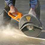
Geophysical Services for Concrete Scanning
Concrete scanning with ground penetrating radar is a fairly well defined application. Unlike X-rays techniques, there is not the issues with unsafe radiation. Concrete scanning with a high frequency antenna can locate many targets within the concrete. For example, post tension cables, buried pipe or conduit, wires, reinforcing bars, and voids. With good site conditions, one may be able to image a trench or a drainpipe, waste pipe, or vent pipe beneath the concrete slab. Above all, note that new concrete, precast concrete with void spaces, and concrete with metal fibers or metal screening often yields undesirable results. When asking for concrete scanning services, be careful who you hire and the level of effort they offer.
Geophysical Services for Concrete Scanning
Geophysical Services for Archaeologists
As a geophysicist registered with the Wisconsin State Historical Society, it is clear that this discipline is one of the more challenging areas in geophysics. By all means, the problem relates to the fact that many of the areas of concern do not yield strong or obvious responses. One is often attempting to map very subtle changes. Subtle changes at depth can affect the electrical properties of the soil (e.g. apparent conductivity, apparent resistivity, and magnetic susceptibility). On a case-by-case basis and for qualified agencies (local, state, and federal government, wildlife agencies, and other government offices), I offer geophysical equipment and services for little or no cost.
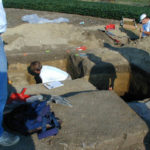
Geophysical Services for Archaeology
A variety of geophysical methods can map disturbances in stratigraphy or the buried remains of a settlement. Any one of these can lead to important archaeological find. A geophysicist or archaeologist can find graves using GPR and other high-resolution methods. For instance, electromagnetic terrain conductivity meters like the EM38 and EM31 that Geonics build. Easier targets include looking for buried metal. In addition to finding iron remains, it is common to hear about an archaeologist using a magnetometer to locate an abandoned fire pit. Some of the more delicate and interesting geophysical methods involve using electrical resistivity methods like an AGI SuperSting R8 with an 84-electrode array or a Geometric OhmMapper, which is a towable capacitance couple resistivity array.
Geophysical Services for Measuring Magnetic Susceptibility
Indeed, magnetic susceptibility is a well known electrical property in physics. In geology, the magnetic susceptibility, more or less, varies with the mineral content. Thus, mine geologists often use this measurement as one metric for locating good ore. A TerraPlus KT-10 can measure the magnetic susceptibility of small geologic samples. A Geonics EM38 or EM31 measures the magnetic susceptibility of larger in situ materials. The volume of material sampled can reach up to 10 feet in diameter. These greater depths of penetration that Geonics instruments offer makes them a great tool for locating buried metal. In addition, human activities can lead to mappable variations in near surface magnetic susceptibilities.
Geophysical Services for Agriculture
Geophysical methods offer assistance with a variety of concerns that agricultural consultants confront on a regular basis. For example, geophysical services assist with measuring soil thickness over bedrock to limit wastewater seepage or to avoid shallow bedrock conditions, mapping fill material, delineating soil conditions, and locating drain tiles. In agriculture, the electrical conductivity or, conversely, the electrical resistivity of soils can correlate to an assortment of soil properties. Crop production and herbicide degradation may correlate well to soil conductivities. In addition, there are published documents that show the concentration of soluble salts, soil moisture, soil type, and soil depth are typical mappable features. Geophysical instruments that measure soil conductivity or resistivity are Geonics EM38, Geometrics OhmMapper, and 4 pin/electrode electrical resistivity. Though the Geonics EM38 offers various depths of penetration, it has a maximum depth of about 5 feet. For greater depths greater, one can use a Geonics EM31.

Geophysical Services for Agriculture
In addition to characterizing soil properties, the farming community frequently needs to relocate existing drain tiles. There a several reasons to do this with few viable options for finding the drain lines. Probing or excavating are often difficult, time consuming, and costly. On the other hand, geophysically imaging a drain tile or line using ground penetrating radar ( GPR ) is common practice. The success is highly dependent on the size, depth of burial, and soil conditions. With good site conditions, one can expect spectacular results. At the same time, lines that are too small, too deep, or in electrical conductive soils will not yield desirable results.
Geophysical Services for Forensic Science
Forensic geophysics is for law enforcement and other legal matters. It is a non-destructive approach for locating evidence found beneath the surface of the ground or water. For instance, I have had the opportunity to search for bodies, graves, guns, excavations, and any other alterations that may enhance an investigation. When searching for graves, I have used GPR (e.g., Sensor & Softwares Noggin and pulseEKKO systems), OhmMapper capacitance coupled electrical resistivity, magnetometers, terrain conductivity meters (e.g. Geonics EM38 and EM31), and multi-electrode electrical resistivity imaging.
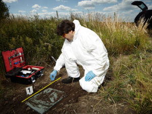
Geophysical Services for Law Enforcement
In my opinion, using only one of these methods may minimize the search effort. An investigator cannot count on using just one geophysical method. Geophysics for forensics is one of the most difficult types of geophysical investigations. The need to find evidence is often much greater than the need for conclusive results. In other words, a geophysical response that is not much greater than background may be of interest. On a case-by-case basis and for qualified law enforcement agencies (local, state, and federal law enforcement, wildlife agencies, and other government offices), I offer geophysical equipment and services for little or no cost.
Locating Deep Facilities Using ERI, EM, MASW, pulseEKKO Ultra GPR, and Magnetometers for Buried Cables Voids Pipes
Geophysics for voids under buildings, floors, foundations, parking lots, and factories
Geophysical Services Conducted. A Short List of Clients, Landfills, Government Sites, and Locations.

Chart Comparing 57 Geophysical Methods With 17 Applications and Disciplines
Less Common Near Surface Geophysical Equipment
NAICS and SIC Codes for Geophysical Surveying and Mapping Services
Geophysics and Geophysical Services From Archives and Old Posts