GPR Costs
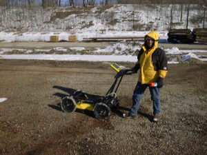
GPR costs have three general categories. There are prices for professional GPR services, services by utility locating and marking companies, and the “rest of the people” or “others.” The GPR costs for “others” are unpredictable. They charge as little as a few $100 to well above the going rates. I am not making any claim that utility locating and marking companies are any better or worse than professional services. Yet, I have found that locate and mark services may cost less given their “walk around” approach. Locate and marking implies that one will walk around with GPR until the operator observes a response. At that time, they place a mark on the ground. This approach often does well for relocating known lines and may cost $500 to a $1000 per visit. However, it is a basic service with a lower level of confidence than professional documented GPR surveys.
Professional GPR surveys include a much wider range of applications as one will discover below. Like all professional geophysical services, there are not any guarantees. On the other hand, I feel a professional GPR survey yields a higher level of confidence because of the greater level of effort. This level of effort should yield, in my opinion, an interpretation based on collecting GPR data using a formal grid, when appropriate. The grid allows the geophysicist or other professional to record data along survey lines. GPR data collected along perpendicular lines allows one to produce plan view maps. In the end, the plan view maps along with the analysis of the GPR cross-sections can assist with differentiating between smaller details and features that are unlikely observed by simply walking around with the GPR system. These services often range from a $1000 to $3000 per day and include a report.
GPR services and applications
Although GPR locate and mark services for private facilities and public utilities are very popular, GPR systems, with their wide range of frequencies, are able to detect and delineate many subsurface features. Here are some more common GPR applications.
GPR for engineers, geologists, geophysicists, archaeologists, and other professionals
Geology and Hydrogeology
Before private facility locating and underground utility locating became popular, GPR systems succeeded to characterize the near surface geology. Imaging bedding planes in overburden and rock played an important role in many studies. Geologists found they had an important tool that allowed them to better visualize the subsurface. In addition to mapping changes in soil deposits, the systems measured the overburden thickness and frequently detailed the local stratigraphy. Observing abrupt changes in bedrock structure and noting unique GPR responses lead to detecting and quantifying joint systems, faults, and sinkholes. Infilled joints, faults, and karst features, with electrically conductive materials like water and clay, are reasonable targets for GPR. Karst features can yield, at times, GPR responses that are not only associated with localized weathering but respond to the void space. Please note that it is often easier to detect a void space than it is to map its shape.
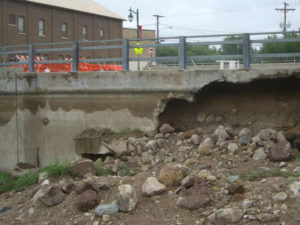
GPR Dam Bridge Washout
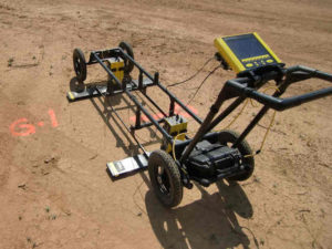
GPR for Mapping Geology
In contrast to an unsaturated void space, a saturated karst feature may provide a response that is associated with a loss of energy. Although the top of a saturated or unsaturated void will often produce a nice reflection, unsaturated voids have a tendency to allow the energy to bounce around inside the void. Whereas, a water filled void may absorb the transmitted signal. Unlike ice, which does not typically inhibit the propagation of the signal, groundwater is electrically conductive and absorbs the energy. However, the dielectric contrast between the water table or other saturated zones and unsaturated material frequently produces a reflection. On the other hand, when a system is in direct contact with the water (e.g., bottom of a non-metalic boat) or on top of ice, the GPR pulse may travel tens of feet and penetrate well into the soils or other materials found at the bottom.
GPR vs a sub-bottom profiler
Thus, in very shallow water, GPR is an alternative for sub-bottom profiling. The acquisition and presentations of the results from a GPR survey and from a sub-bottom profile survey are very similar. In very shallow water, one may not notice a difference between a GPR record and a sub-bottom profile record. The primary difference is that GPR transmits a radio wave while sub-bottom profilers produce an acoustic energy pulse, often from a chirper or a pinger. Though GPR is nowhere near as robust as an echosounder or a depth locator, it provides good bathymetry over shallow freshwater. Note that GPR does not yield desirable results over saltwater. The highly conductive saltwater quickly absorbs the electromagnetic signal. At the same time, GPR works well for imaging saltwater intrusion in areas with good site conditions.
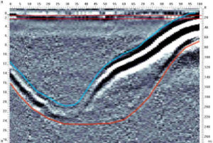
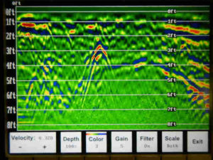
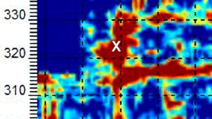
50mhz GPR Image of Pond Sediments
GPR for Mining Operations
Open pits, quarries, and underground mines all benefit from GPR services. When conducted over clean sand and gravel, GPR can penetrate 30 to 50 feet of material. A monitoring program where one images the sand and gravel deposit as the bottom of the pit deepens can assist with identifying problems with the presence of unwanted clay units. The pit operation can then decide to avoid the clay rich zone or find a way to blend the material with good stone or process it separately. Occasionally, operations cannot afford or are not able to mine below the top of water. GPR can assist with locating and monitoring water-bearing zones that may hinder a mine operation. For example, one can monitor the progress made from pumping cement into a formation to stop the flow of water.
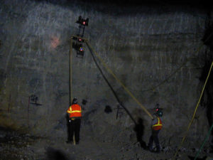
GPR for Imaging Mine Conditions
Mine safety is an ongoing program. In underground operations, fault zones can yield poor quality product. Furthermore, faults often compromise the integrity of the mine ceiling, which may lead to dangerous overhead conditions. Faults also act as a conduit for water. It is not uncommon for a fault to intersect a retention pond, drainage ditch, or other body of water that drains into the mine operation. Often imaging the floor or ceiling of a room or the walls of a pillar can assist with mapping possible zones of interest across an underground mine. Mapping the ceiling thickness or characterizing the condition of the ceiling can improve a mine’s safety program.

GPR in Environmental Studies
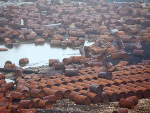
Buried drums are an excellent target for GPR unless there is too much clay cover. Trenches dug to bury drums, animals, municipal waste, and dispose of hazardous liquids may be located using GPR. Though attempting to locate underground storage tanks ( UST’s ) or anything buried under many feet of clay is a poor idea, GPR is known to locate UST’s. Personally, I find EM31 and a magnetometer surveys often provide results that are more reliable for less money. Preferential paths like pipes or gravel drainage trenches, tile lines, storm drains, and sewer lines may show up as anomalies in a GPR record. Septic systems and septic tanks frequently produce desirable results. Unlike preferential paths that allow fluids to flow, buried foundations, walls, and other structures can control the flow of contaminated groundwater (also uncontaminated groundwater). Buried walls and buried concrete basins are targets that GPR can image.
GPR for Environmental Studies
Contamination is an environmental issue. Liquids that are electrically more conductive or less conductive than the surrounding in situ materials may produce a GPR response that is inconsistent with adjacent areas that are uncontaminated. For example, I conducted a survey at Wurstsmith Air Force base where jet fuel contaminated the near surface soils, which were sand rich. Normally, one would not expect to map a plume created by electrically resistive jet fuel in sand. Nonetheless, I was able to map the plume. Later and obviously without being told prior to conducting the GPR survey, I found out the jet fuel was being digested my small organisms. The process is known as biodegradation. The waste product of the organisms was very conductive. In the end, I used GPR to map an electrically conductive contaminate plume in sand.
Utility locating and private facility locating
Using GPR to locate or find underground public utilities and private underground facilities falls into two types of services. The two services are operators licensed to locate public lines and those who are not. I am not licensed or permitted to locate public utilities, even though they are observed. Thus, my discussion here focuses on private lines, even though the topics may relate to public utilities. Here is a list of underground features that a GPR survey may detect or locate. This partial list includes metal pipes, metal cables, metal electrical conduits, PVC or plastic electrical conduits that have cables inside or are larger in diameter or shallow if wireless, concrete pipes or its trench, ducts, vaults, corridors, manhole covers, storm drains, and shut off values.
Locators frequently refer to equipment designed to trace buried pipes and cables as underground utility locators, underground pipe locators, or underground cable locators. Although these locators use electromagnetic energy or radio waves to trace buried lines, this is not the same as GPR. Locators depend on a transmitted signal, which follows a metal conductor or line, to radiate off the underground line into the surrounding material. The operator than traces or locates the radiated signal where it emerges at the surface. Many surprised excavators have found that the line locator’s signal may not have surfaced directly above the line of concern. In contrast, GPR transmits a signal into the ground and maps lines that reflect the signal back to the surface. Undoubtedly, two different types of technologies. In general, I find that underground line locators may offer greater depths of penetration but are less likely to locate unknown concerns.
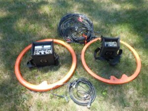
Locate Underground Cables, Wires, and Pipes
Suite of geophysical equipment
In my opinion, no one brand of line locator or geophysical instrument can do an entire survey. As a minimum, an operator should consider using one or more underground line locators with GPR and a Geonics EM31 or EM61. This makes up a suite of instruments for locating underground lines. Engineers and other professionals frequently use subsurface utility engineering or SUE surveys. As Wikipedia defines it, “The SUE process begins with a work plan that outlines the scope of work, project schedule, levels of service vs. risk allocation and desired delivery method. Non-destructive surface geophysical methods are then leveraged to determine the presence of subsurface utilities and to mark their horizontal position on the ground surface…SUE is gaining popularity worldwide as a framework to mitigate costs associated with project redesign and construction delays and to avoid risk and liability that can result from damaged underground utilities.”
GPR for scanning concrete and asphalt
I can go into detail about these services. However, it is best that one visits my site called ConcreteScanner.com. Here is a partial list of targets or features that high resolution GPR may detect or locate (metal pipes, metal boxes, electric cables and lines, plastic and/or metal conduits, post-tension cables, reinforcing material, rebar, voids, slab thickness, pavement thickness, drain lines, vent lines, waste lines, and sewer or septic lines).
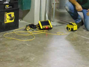
Concrete Scanning
GPR in Archaeology
GPR results, like many tasks in archaeology, can take time to understand. Gross anomalies are easy to interpret and often lead to finds that would take months or even years to locate. In my opinion, GPR offers a method to conduct a type of pre-excavation triage. The evaluation process leads to locating anomalies that have various levels of interest. One may also find that using a variety of frequency antennas, the site may yield better results. Given the usual desire not to miss a find and the sensitivity of the instrument, which can map anomalies unrelated to human activity, one should expect false positives. On the other hand, the problem of false positives is less of an issue with larger structures and larger subsurface disturbances.
I believe that certain archaeological studies could clearly benefit form an ongoing GPR monitoring program. The collection of GPR data at multiple horizons, as the archaeological excavation advances, is one way to stay informed. Since soil conditions can strongly affect the results, surveys conducted as the excavation increases by 0.5 to 1.5 feet may lead to new findings. Certainly, there would be overlap in the results; however, the response may greatly improve after removing a foot or so of material. For example, the disturbance from an excavation (like a burial), the footprint of a wooden building or an earthen construction (not made of stone), or demolition material left behind from past structures can create anomalies, though often subtle. Again, the greater the sensitivity the greater the chance of mapping anomalies from conditions unrelated to human activity. Thus, the likelihood of more false positives.
Cemeteries and graves
Archaeologists use GPR surveys to locate cemeteries, unmarked burials, paupers graves, marked graves, and metal grid layout markers. Grid markers can be very small and difficult to locate; but they do show up in a GPR survey or with a magnetometer. On a large scale, using GPR to map out areas interpreted as undisturbed or in situ is one way to locate the outer boundaries of a cemetery. Higher resolution methods using closely spaced perpendicular survey lines are able to image graves. Large-scale discontinuities within a cemetery may be an indication of the removal or relocation of graves. Locating subtle subsurface features like a grown over walkway or covered road can assist with reconstructing the layout of a cemetery or other archaeological site.
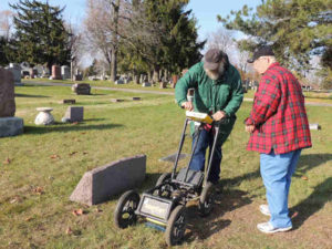
GPR for Graves and Archaeology
GPR for law enforcement, forensic science, and military applications
Law enforcement agencies benefits from many of the topics discussed for archaeologists. That is, looking for targets or features from recent human activity, using GPR, is not much different from the results provided to archaeologists. Some of the differences pertain to newly buried remains or recent burials. Recent burials may produce a good reflection. The void space taken up by a body is a reasonable target for GPR, given good site conditions. Conversely, trying to locate individual bones may lead to many false positives. Buried evidence constructed of metal is frequently a good target. Also, packages or containers that are large enough to image and made of materials that are inconsistent with the surrounding materials may yield desirable results.
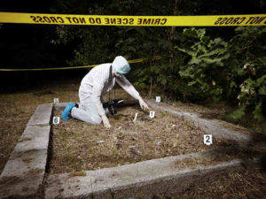
Law Enforcement
Military uses for GPR cover a wide range of applications. Most of the discussion on this page can apply to the military. Applications range from imaging concrete structures for radio towers to locating unexploded ordinances, landmines, tunnels, and rooms.
GPR in agriculture, farming, and golf courses
Though most of my experience in agriculture is farming, forestry and water management are other areas using GPR. Locating buried pipes, power lines, and other types of cables are an issue for farmers. Locating metal spikes and mapping the condition of a tree are possible concerns for foresters. Golf courses offer a range of possible features to map. Many golf courses need to image a range of targets, which include locating drain tiles before reconstruction, wanting to characterize the construction of an existing tee or putting green.
Mega farms
Some mega farms are a combination of many smaller farms. A mega farm that now owns many smaller operations that were once family owned can lead to unexpected consequences. Smaller family operations may not have always kept good written documentation. This can range from the previously mentioned undocumented pipes, cables, and wire to the thickness of concrete slabs and the location of field tiles. Mapping field drain tiles using GPR is a make or break type of application. When the soil conditions are good and the tile lines yield good reflectors, operators can map out miles of drain tiles. On the other hand, moving into an area that is clay rich may be a challenge because of the lack of penetration. In those cases, one may have a better chance of locating the gravel that fills the trench than the drain line.
Locate Drain Tiles
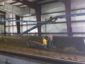
One of the most interesting and unusual GPR investigation that I conducted was for a mega farm. The farm had an open concrete basin that churned and dried cow manure. By the time the manure reached the far end of the basin, it was dry enough to burn in a steam power plant. The problem was that the manure pile ended up with unexpected objects that could damage the drying process. These objects would damage or break the paddles that churned the manure. In the end, with many wooden planks for support, GPR was able to successfully image many targets in the open basin of manure. The mega farmer removed the objects and was able to get the old manure grinder back up and running.
GPR for snow and ice
Be aware that GPR is compromised by wet surface conditions and can limit the depth of penetration. Otherwise, snow and ice do not conduct electricity fairly well. GPR likes frozen fresh water. Thus, GPR can image snow and ice conditions at most locations. Without doubt, snow thickness is crucial to ski hills and resorts. GPR not only can assist with determining the thickness of snow, at times it can assist with characterizing the condition of the snow pack. Being able to manage and allocate their primary resource, snow, makes a ski hill or resort more efficient. Winter destinations are not only concerned about the ski hills. They also have many ski trails and snowmobile trails that require routine maintenance.
Mapping ice thickness with GPR can be difficult with an auger or drill. Surely, one understands that lakes and other inland waterways that people drive on in the winter need monitoring. I have been in the Arctic Circle on sites where drill rigs and other large equipment relied on the ice to support their equipment. GPR was a great way to determine not only the initial ice conditions but to monitor changes that occurred during the winter season.
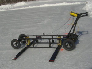
GPR Over Snow and Ice
Locating Deep Facilities Using ERI, EM, MASW, pulseEKKO Ultra GPR, and Magnetometers for Buried Cables Voids Pipes
Geophysics for voids under buildings, floors, foundations, parking lots, and factories
Geophysical Services Conducted. A Short List of Clients, Landfills, Government Sites, and Locations.

Chart Comparing 57 Geophysical Methods With 17 Applications and Disciplines
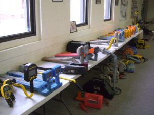
Less Common Near Surface Geophysical Equipment
NAICS and SIC Codes for Geophysical Surveying and Mapping Services
Geophysics and Geophysical Services From Archives and Old Posts